The Oxford Flood Alleviation Scheme
A new stream to the West of Oxford
The Environment Agency is working with partners including Vale of White Horse District Council on a scheme to reduce the risk of flooding from the River Thames to all homes and businesses in Oxford, as well as to services and major transport routes into the city.
The planning application for the project was approved by Oxfordshire County Council in July 2024. In May 2025, the Secretary of State for Environment, Food and Rural Affairs (Defra) confirmed the scheme’s Compulsory Purchase Order (CPO). This means the Environment Agency can now progress with purchasing the rights and interests in land that it needs to build the scheme – most of the land is farmland and floodplain meadow, and it has already consulted with landowners and affected parties and will continue to do so. The CPO brings certainty to our plans and the scheme closer to reality, to ensure reduced flood risk in Oxford.
More info on the planning application approval is on our news page.
Starting north of Botley and ending three miles later at Kennington the scheme will involve lowering parts of the floodplain and working on some of the existing rivers and streams that run through it to make more space for water and reduce flood risk to the city.
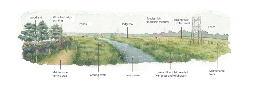
As well as reducing flood risk, the scheme will create more than 20 hectares of new wetland and improve existing public footpaths and bridges.
Further details can be found on
The Oxford Flood Alleviation Scheme webpage (government website)
The OFAS engagement page (dedicated Environment Agency page where you can sign up for regular updates)
And on the Oxfordshire County Council Alleviation Scheme page
An independent review of the Oxford Flood Alleviation Scheme confirms scheme will NOT put downstream communities at greater risk.
In 2017 the council commissioned Water Resource Associates to carry out an independent review into the potential impact of the Oxford Flood Alleviation Scheme. This followed local concern from downstream communities in the Vale that the Oxford scheme could increase their flood risk.
The results of the independent review confirm that the Oxford Flood Alleviation Scheme will NOT put communities downstream at any greater risk of flooding and support the modelling previously carried out by the Environment Agency. To read the full report click on the button below .